
Three Locations in One! | Mill Creek Falls, Barr Creek Falls, and Avenue of the Boulders
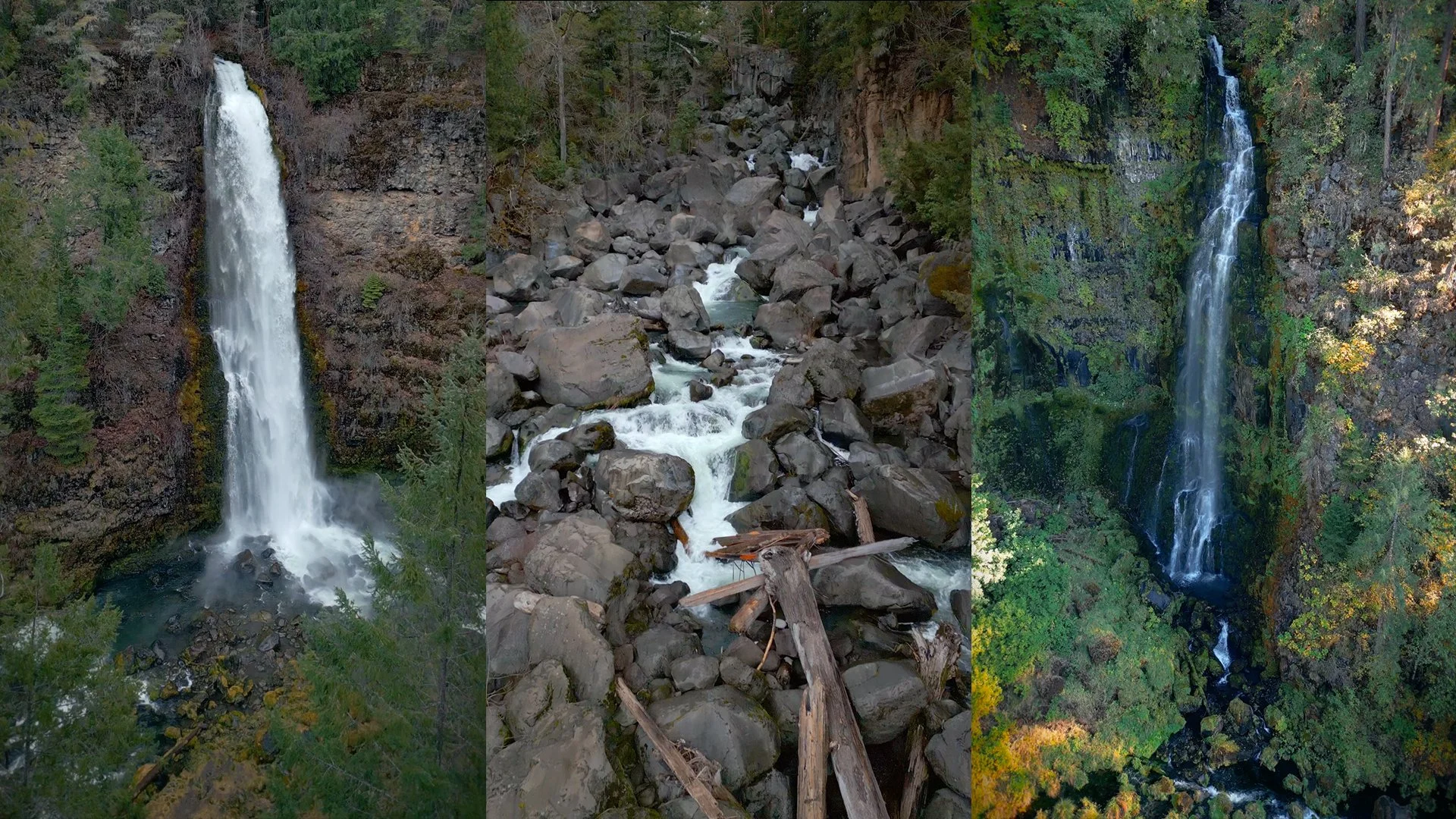
Just outside Prospect, Oregon, one short trail system takes you to two waterfalls and a stretch of the Rogue River filled with enormous boulders. Mill Creek Falls drops into a forested canyon, Barr Creek Falls spills down the cliffs nearby, and Avenue of the Boulders gives you a completely different view of the river.
I like this hike because there's quite a bit to see without covering a long distance. My route is about 1.5 miles round trip, with the waterfalls first and the boulders on the way back. And there's one more viewpoint near the bridge that I think is worth stopping for before you leave.
Video Walkthrough Guide
Click the Play Button above for the Video Guide, or continue down to read the Full Review.
Quick Facts
- Difficulty: Easy*
- Hike Length: About 1.5 miles*
- Elevation Gain: About 213 ft.*
- Hike Type: Out & back with spurs
- Pass Required: None**
- When to Visit: Year-round***
- Pets: Dogs on leash
- Kids: Yes, with close supervision
- Facilities: Portable toilet, picnic tables**
*Distance and elevation are approximate and depend on which paths and viewpoints you include. The main outing is short, but there are slopes, steps, uneven ground, and exposed canyon edges. Exploring among the boulders is different from walking the main trail.
**Check posted information when you arrive. Facilities and access arrangements can change, so don't rely on a portable toilet always being available.
***Year-round access depends on conditions. Snow, ice, storms, and wildfire closures can affect your visit.
Can you visit all three places on one hike? Yes. Mill Creek Falls, Barr Creek Falls, and Avenue of the Boulders connect to the same trail system. I recommend seeing the two waterfalls first, then returning to the main junction and heading toward the boulders.
How long is the hike? Plan on roughly 1.5 miles round trip for the route described here. The shorter entrance, side paths, and time spent exploring can change your total distance. The extra viewpoint near the bridge is a separate stop after the hike.
Is this an easy hike for families? I'd consider the main hike easy, but that doesn't mean every viewpoint is suitable for every visitor. There are steep drops beside the waterfall overlooks, and the boulder area has uneven footing and moving water. Keep children close and dogs on a leash.
How tall are Mill Creek Falls and Barr Creek Falls? Mill Creek Falls is about 173 feet tall. Barr Creek Falls totals about 240 feet across three drops, with a final drop of about 150 feet. You aren't looking at one uninterrupted 240-foot plunge from the main viewpoint.
What else is nearby?Pearsony Falls is another stop in the Prospect area. If you're exploring farther along Highway 62, you can also visit the Rogue River Gorge.
Getting to the Trailhead
The Mill Creek Falls and Avenue of the Boulders trailhead is just off Mill Creek Drive, a few minutes from Prospect in southern Oregon. Use the trailhead location in the map below so you arrive at the parking area for this hike.
There's a fairly spacious parking area, with picnic tables and a portable toilet noted during my visit. It's a handy place to have a snack before setting out or take a break when you get back.
Choosing Your Route onto the Main Trail
From the picnic area, there are two ways to reach the main trail. To the left of the picnic tables, a shorter but steeper path drops down to the old fire road that serves as the main route. To the right, a longer option follows along the road before joining that same trail on a more gradual slope.
Once you're on the main trail, you'll pass a spur on the right that offers a shortcut toward the waterfalls. You can take that option or stay on the main route until you reach the larger signed junction.
At that junction, Avenue of the Boulders is to the left, while Mill Creek Falls and Barr Creek Falls are to the right. I recommend going to the waterfalls first and saving the boulders for the return trip.
Mill Creek Falls: The First Waterfall Stop
The trail descends through forest with Douglas-fir, grand fir, and madrone trees. Large rock formations appear along the way, so there's plenty to notice before you reach the canyon views.
After the switchbacks, you'll come to a clearing with another trail split. Take the left path for the Mill Creek Falls viewpoint.
Mill Creek Falls plunges about 173 feet into the canyon below. The trees frame the waterfall across the gorge, with the cliff face and surrounding greenery helping show just how far the water drops. It has a powerful appearance that contrasts nicely with the thinner flow you may see at Barr Creek Falls.
This is a good place to spend a little time taking photos, but the viewpoint is beside a steep cliff. Watch your footing and stay well back from the edge, especially with kids or dogs. Getting closer to the drop isn't necessary for a good view.
When you're ready, retrace your steps to the nearby trail fork to continue toward Barr Creek Falls.
Barr Creek Falls and the Rock Terrace
From the fork near Mill Creek Falls, follow the branch toward Barr Creek Falls for roughly another quarter mile. The route continues through greenery and moss-covered rocks before reaching a small staircase up to a rock terrace.
The terrace is the main spot to take in Barr Creek Falls. The waterfall drops in several stages, totaling about 240 feet, rather than falling that whole distance in a single plunge. Its final drop is about 150 feet, and the upper sections aren't all equally visible through the trees.
Barr Creek can have a much fuller flow in spring and a thinner, more delicate appearance later in summer. That difference is part of what makes seeing both waterfalls interesting. They're close together, but they don't look or feel quite the same.
Madrone trees shade the terrace, and I think it's a nice place to pause before heading back toward the boulders. Keep the canyon edge in mind here too, and choose a resting spot well away from the drop.
Avenue of the Boulders and the River-side Spur
After seeing both waterfalls, retrace your steps back to the main signed junction toward the beginning, and follow the trail marked for Avenue of the Boulders. Use the signs when you're coming back from the falls, rather than relying on the left-and-right directions from your initial approach.
As you head down, the boulders become more noticeable among the trees. By the time you reach the river, some of the rocks are enormous. The Rogue River runs between them, with cliffs and forest surrounding the boulder field.
These massive rocks are remnants of Mount Mazama's eruption about 7,700 years ago, the same eruption that formed the basin now filled by Crater Lake. It's a pretty interesting connection to keep in mind while you're looking at the boulders scattered along the river.
It's worth taking a little time to look at the shapes and spaces between the rocks. There are rounded surfaces, crevices, and openings that give the area a very different character from the waterfall viewpoints. You don't need to climb high onto the boulders to appreciate their size.
Just before the main boulder field, watch for the sign pointing toward the river. A small trail leads toward the water and gives you another way to enjoy the canyon without making scrambling the focus of your visit. This is one of those little side stops that's easy to miss if you're only looking for the main attraction.
Use extra care around the river and rocks. Smooth or wet surfaces can be slippery, gaps between boulders can be awkward, and the current is powerful. Stay on open, established routes, follow posted signs, and skip any scramble that doesn't offer secure footing. Exploring beyond the main trail is at your own risk.
The Extra Viewpoint near Prospect
There's one more stop I recommend before leaving the area. After returning to your car, head back toward Prospect. Just after crossing the bridge over the Rogue River, look for the small parking area on the right.
From there, a short trail leads to a higher view over Avenue of the Boulders. It's a different perspective from being down beside the rocks. You can see more of how the river winds through the boulder field and how the canyon fits around it.
There wasn't a safety fence at this viewpoint when I visited, and the cliff drops away steeply. Stay well back from the edge and use extra caution. If the route or footing doesn't feel comfortable, leave this extra stop out of your visit.
Final Thoughts
Two waterfalls and a boulder-filled stretch of river make this a really worthwhile stop near Prospect. I like that the hike gives you several different places to pause, rather than taking you to one viewpoint and straight back to the car.
My preference is still to visit Mill Creek Falls and Barr Creek Falls first, then leave a little time for Avenue of the Boulders. Don't overlook the smaller river-side trail or the extra viewpoint near the bridge if conditions are suitable. Those different perspectives are a big part of what makes this place interesting.
If you have more time, take a look at my guides to Pearsony Falls and the Rogue River Gorge for other nearby stops.
Happy exploring 🌿


