
Watson Falls: A Short Hike to Oregon’s 3rd Tallest Waterfall
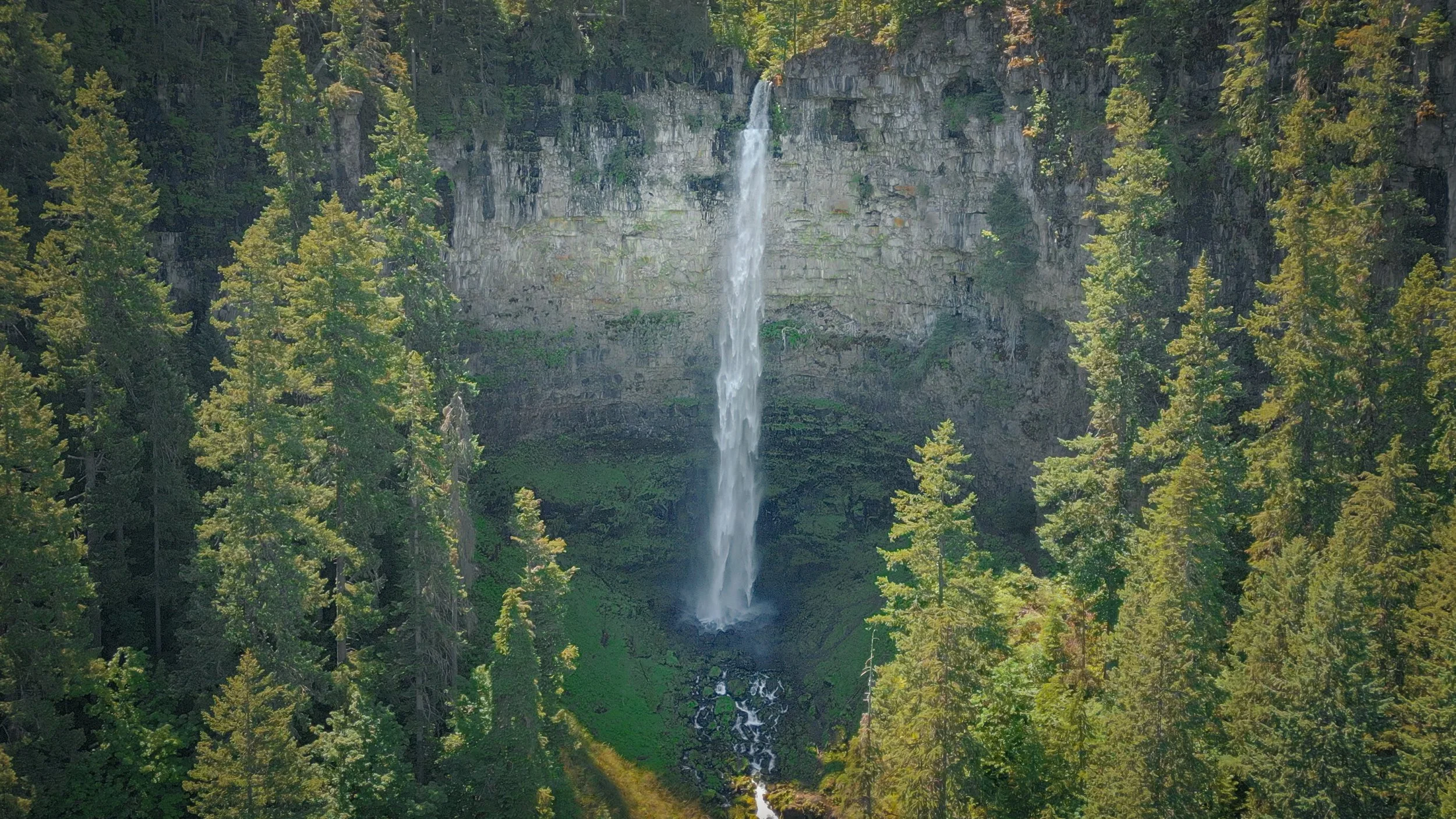
Often described as Oregon’s third-tallest waterfall, Watson Falls drops nearly 300 feet over a tall basalt cliff in the Umpqua National Forest. The trail is only about 0.8 miles, but it packs in a pretty steady climb, incredibly large boulders, views of Watson Creek, and several places to stop and take in the waterfall.
The falls are the main reason to come, but I think the creek and forest deserve some time, too. There’s a quiet picnic area near the parking lot, small cascades along the way, and a wooden bridge with a beautiful view upstream. If you’re exploring the waterfalls along Highway 138, Watson is an easy one to combine with nearby Toketee Falls.
In this guide, I’ll walk through getting to the trailhead, what the hike is like, and the viewpoints along the way.
Video Walkthrough Guide
Click the play button above for the video guide, or keep reading for the full trail guide.
Quick Facts
- Difficulty: Moderate
- Hike Length: 0.8 miles
- Elevation Gain: 433 ft.
- Hike Type: Loop
- Pass Required: None
- When to Visit: Spring–fall*
- Pets: Dogs on leash
- Kids: Yes, with care**
- Facilities: Vault toilet
*Check current Forest Service information and posted signs for any changes to fees or access. Snow, ice, wildfire restrictions, and road closures can affect your visit.
**The trail has uphill sections, rock steps, and slippery areas, so the short distance doesn’t necessarily make it an easy walk for every visitor.
How long is the Watson Falls hike? The loop is about 0.8 miles with roughly 433 feet of elevation gain. It’s a short hike, but leave yourself time for the climb and stops along the creek and at the waterfall viewpoints.
Is the Watson Falls trail easy? It’s generally rated moderate. The distance is manageable, but the incline, rock steps, and uneven footing make it more demanding than a flat walk of the same length. Take your time, especially on the way down.
How tall is Watson Falls? Watson Falls is often called Oregon’s third-tallest waterfall. The Northwest Waterfall Survey lists it at 293 feet and describes a Forest Service measurement of 292.7 feet. Some Forest Service materials and AllTrails still list 272 feet, so you’ll see both figures, and rankings vary depending on which waterfalls are counted. Either way, it has a much bigger presence than the short hike might suggest.
Can you bring dogs or children? Dogs are welcome on leash. Children who are comfortable with an uphill trail may enjoy it, but keep them close around the creek, steps, and viewpoints. Wet rocks and spray can make the footing slippery.
Can you visit Watson Falls and Toketee Falls on the same trip? Yes. They’re a short drive apart along Highway 138, and both have short trails. You can also add Clearwater Falls or Whitehorse Falls if you’d like a couple of shorter stops.
Getting to Watson Falls
Watson Falls is just off Highway 138, about 60 miles east of Roseburg in the Umpqua National Forest. Around milepost 61.3, turn south onto Forest Road 37. The parking area is about 0.2 mile down the road on the right.
This makes Watson a convenient stop while exploring the North Umpqua waterfall corridor. You don’t have a long drive on forest roads to reach the trailhead, but it’s still worth checking road and weather conditions before leaving. Snow and ice can change the trip quite a bit in winter, and summer access can be affected by wildfire restrictions.
Parking and Facilities
The parking area is fairly spacious, and there’s a vault toilet at the trailhead. There are also benches and picnic seating nearby if you’d like to stop before or after the hike.
Use the designated parking area and follow any posted restrictions if it’s full. I wouldn’t count on roadside parking being available. Before leaving the lot, take a moment to check the trail information and any notices about current conditions.
The Creekside Picnic Area
Before heading up the main trail, there’s a little spot near the parking lot that I think is worth seeing. Just before the stairs, a short path on the right leads toward the creek and picnic benches.
Water flows between moss-covered rocks, with trees and foliage tucked around the creek. It’s a nice place to sit for a few minutes, even if you haven’t brought a picnic. The waterfall gets most of the attention here, but these smaller creekside views are part of what makes the whole area so beautiful.
When you’re ready to hike, head back toward the stairs and cross the road carefully to reach the main trail.
Hiking the Watson Falls Trail
The trail starts climbing through the forest fairly quickly. Douglas-firs rise overhead, while ferns and moss-covered boulders fill in the space beside the path. You’ll also hear Watson Creek as you make your way uphill.
Although the loop is less than a mile, there’s enough climbing to make it feel like a real hike. Rock steps and uneven sections break up the trail, and you may want a few pauses along the way. There’s no need to rush. Some of the best parts of this walk are the places between the parking lot and the main waterfall.
Shoes with good traction are a good idea. The forest can hold moisture, and the areas closer to the falls may be wet from spray even when it hasn’t been raining.
Views of Watson Creek
Along the early part of the climb, there are places where you can see Watson Creek flowing around large boulders. The smaller cascades, green moss, and ferns make these views worth stopping for. In fall, the leaves add another layer of color around the water.
Stay on established paths and choose viewpoints with secure footing. You don’t need to climb onto wet rocks to enjoy the creek. There’s also a bench along the trail where you can take a break before continuing uphill.
The First Waterfall View and Wooden Bridge
After more climbing and rock steps, the forest opens enough to give you a view of Watson Falls in the distance. Seeing the water drop from that high cliff gives you a better sense of what’s ahead.
I think this section of the creek is especially beautiful. Water moves between large mossy boulders, and there’s plenty to look at before you even reach the main viewpoint.
A little farther along, the trail passes between boulders and reaches a wooden bridge that bends across Watson Creek. From the bridge, you can look upstream toward the falls and down at the water moving underneath. It’s a good place to pause for a photo while leaving room for other hikers to pass.
The Watson Falls Viewpoints
After crossing the bridge, go left at the signed fork to continue toward the waterfall viewpoint. The trail continues through the forest and rocky terrain before opening to a much closer view of Watson Falls.
There’s a bench where you can sit and take in the tall drop and the basalt wall behind it. The first time I stood here, I was in awe. The creek and smaller cascades are beautiful, but the scale of the waterfall is something else when you’re looking up from the trail.
The route continues uphill through switchbacks to another viewpoint. This last climb is steeper, so take it at your own pace. The closer view brings more of the cliff and falling water into focus, and you may feel the mist drifting across the trail.
Stay within the established viewing areas and respect the railings. The spray is part of the experience, but it can make nearby surfaces slick. If you’re photographing the falls, it’s helpful to keep a lens cloth handy.
Returning to the Trailhead
Head back down to the signed junction when you’re finished at the viewpoints. You can retrace the creekside route or follow the other branch to complete the loop.
The loop takes you through more of the forest instead of staying beside the creek. It has fewer water views, but the tall trees and mossy surroundings make it a nice change for the return walk. Watch your footing on the descent, especially if the trail is wet.
As you reach the lower part of the trail, you’ll come back toward Watson Creek before returning to the parking area.
Final Thoughts
Watson Falls is a short hike with quite a bit to see along the way. The tall waterfall is definitely the highlight, but I’d leave time for the creek, the bridge, and a few quiet stops in the forest, too.
If you’re planning a day along Highway 138, take a look at my guides to Toketee Falls, Clearwater Falls, and Whitehorse Falls. Each has a different feel, and they work well together if you have the time.
Happy exploring 🌿
Can’t visit anytime soon? Watch my Watson Falls Cinematic Nature Escape for changing views of the falls with natural sounds.
Gallery


Trailhead Location
Nearby Locations


Also See

Watson Falls: Relaxing Nature Escape
Experience the calming beauty of Watson Falls, Oregon’s third tallest waterfall, as it plunges 293 feet into a lush, moss-covered canyon in the heart of the Umpqua National Forest. This 15-minute video features the soothing sounds of cascading water, rustling leaves, and the peaceful ambiance of the surrounding forest—perfect for relaxation, meditation, or focus.