Twin Sisters Rock | Ancient Basalt Formations at Washington’s Wallula Gap
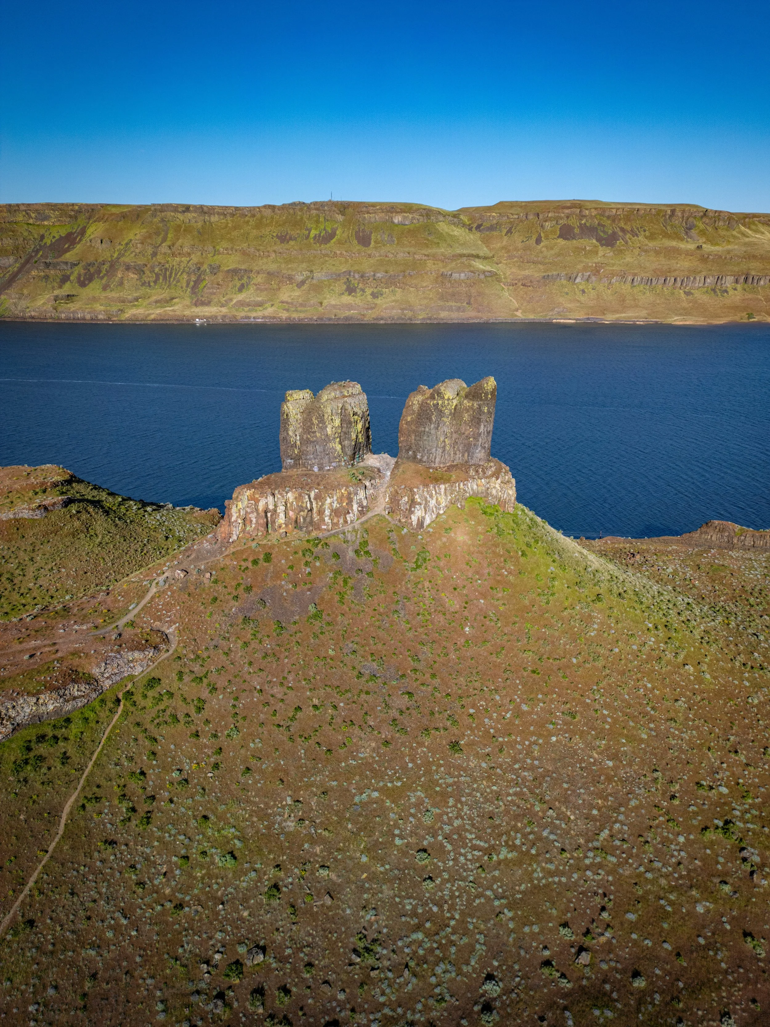
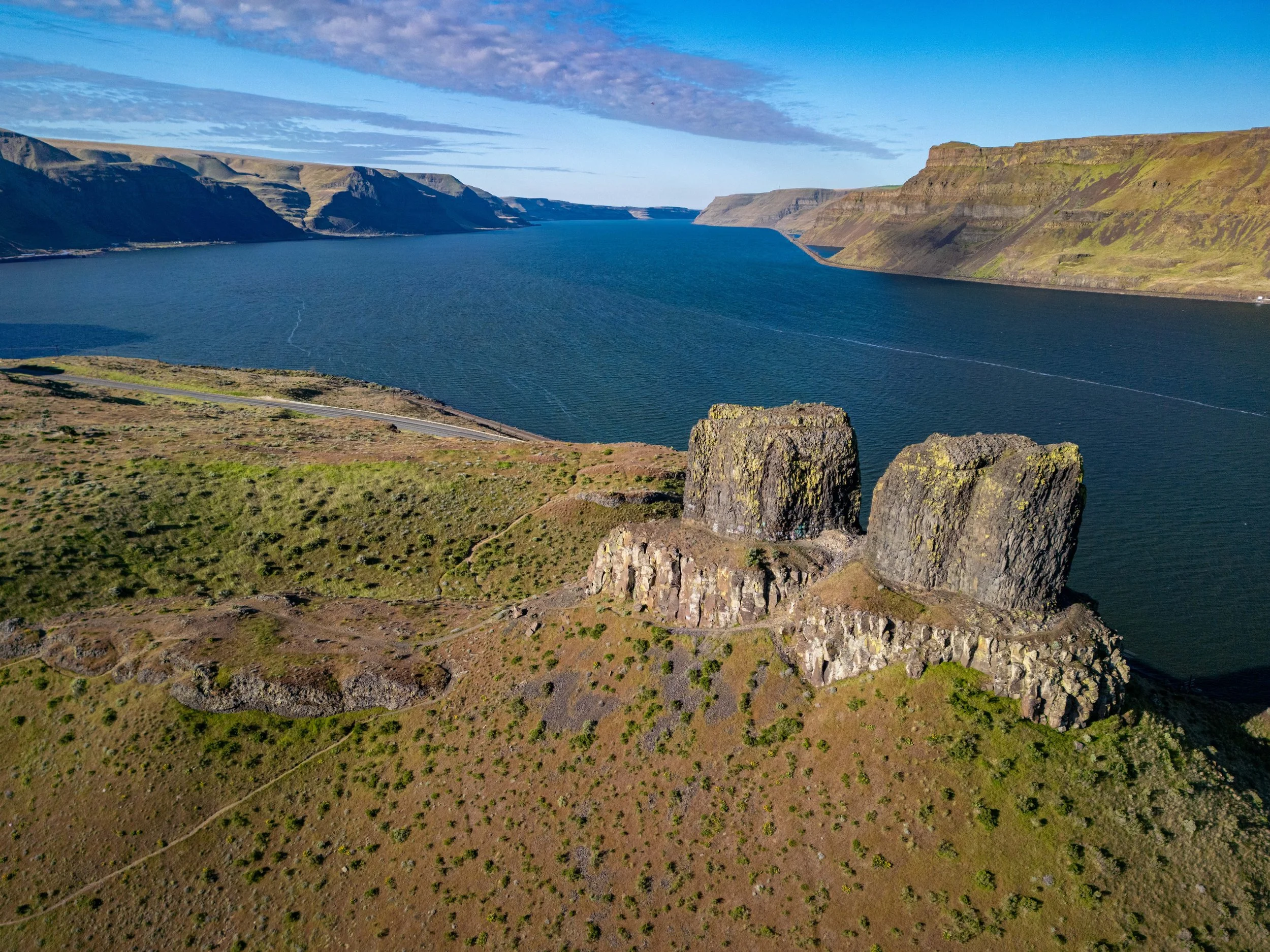
Standing at the edge of Wallula Gap in Washington State, Twin Sisters Rock is unlike anything else I've come across in all my hikes through the Pacific Northwest. Two ancient basalt pillars rise roughly 300 feet above the Columbia River — dramatic, freestanding columns that jut skyward from the cliffs like something out of a different world entirely. Located just off Highway 730 about 20 miles outside of Pasco, this site is managed by Walla Walla County and requires no pass to visit. And yet somehow, despite sitting right along one of the most traveled stretches of highway in Eastern Washington, most people drive right past it without ever stopping.
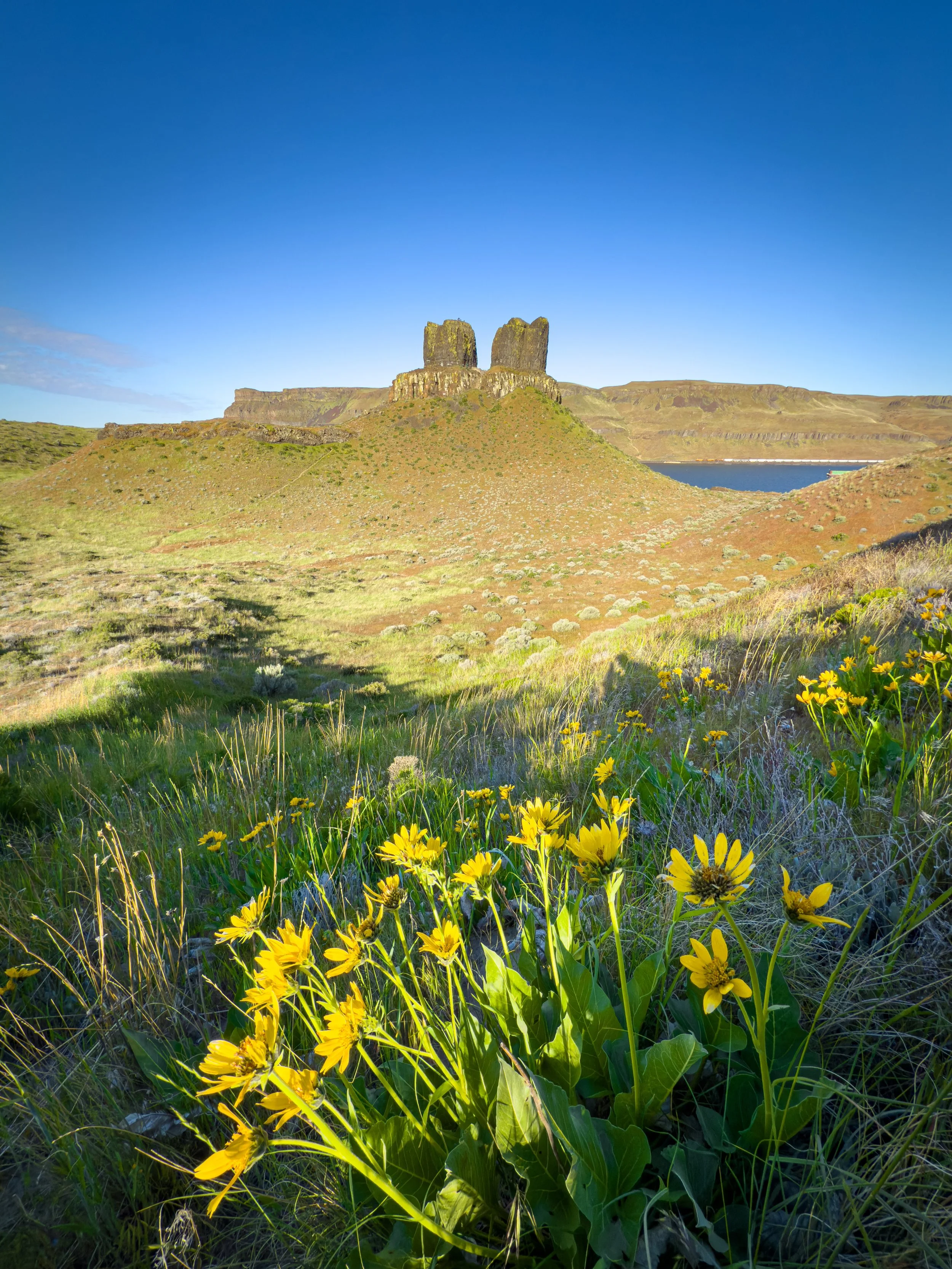
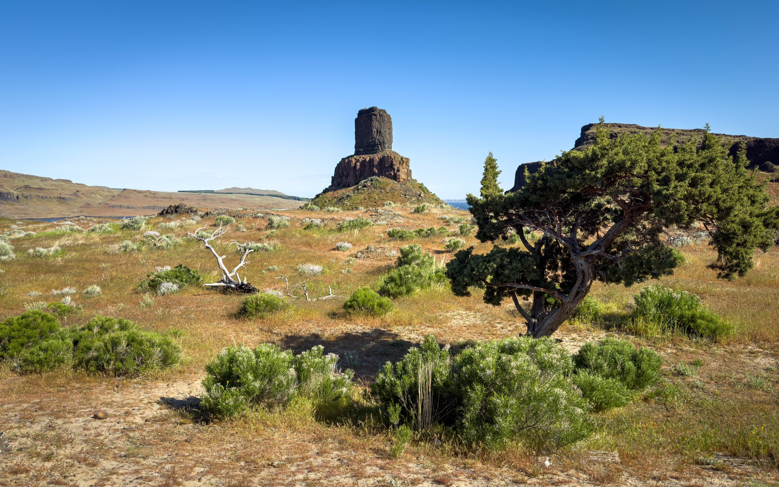
What makes Twin Sisters Rock so rewarding is everything that surrounds the formations themselves. There are more trails out here than most people realize — winding across ridges, through a surprising valley of sand dunes, past smaller basalt formations, and up to multiple viewpoints overlooking the Columbia River. Come in spring and the hillsides are blanketed in balsam-root, snake river daisy, and wild begonia. Come any time of year and you'll find sweeping views, big open skies, and the quiet drama of a landscape still bearing the marks of one of the most powerful geological events in North American history. It's a hike that earns far more than its distance suggests.
Video Walkthrough Guide

Click the Play Button above for the Video Guide, or continue down to read the Full Review.
Quick Facts
- Difficulty: Easy
- Hike Length: 1.0 Miles
- Elevation Gain: 213 ft.
- Hike Type: Loop
- Pass Required: None
- When to Visit: Spring – Fall*
- Pets: Dogs on Leash
- Kids: Yes, with caution (rattlesnakes present)
- Facilities: None
*Summer heat in this area can be extreme — temperatures regularly exceed 100°F in July and August. Early morning visits are strongly recommended in summer. Spring and fall offer the most comfortable hiking conditions.
Is Twin Sisters Rock worth visiting? Absolutely, especially in spring. The basalt pillars are genuinely dramatic up close, the Columbia River views from the ridgelines are some of the best you'll find on a short hike in Eastern Washington, and the wildflower display in late April and May is stunning. For a 1.0-mile loop with no pass required, the payoff here is outstanding.
When is the best time to visit Twin Sisters Rock? Spring — roughly late March through May — is the standout season, when balsam-root and other wildflowers blanket the hillsides around the formations. Fall is also excellent with comfortable temperatures and clear views. Summer visits are possible but be aware that this is exposed high desert terrain with no shade, and temperatures can exceed 100°F. If you visit in summer, go early in the morning.
How difficult is the hike to Twin Sisters Rock? The trail is rated Easy and the total loop is approximately 1.0 mile with 213 feet of elevation gain. Most hikers complete it in 30–60 minutes. The terrain is a mix of packed dirt and loose sandy soil — especially near the base of the formations — so sturdy footwear is recommended.
Are there rattlesnakes at Twin Sisters Rock? Yes — rattlesnakes are common in this habitat, particularly in warmer months. Stay on the trail, watch your step around rocks and tall grass, and be especially alert during warm afternoons. Early morning visits reduce the likelihood of an encounter.
Do I need a permit or pass for Twin Sisters Rock? No pass or day use fee is required. The site is managed by Walla Walla County and is free to visit. There are no facilities at the trailhead, so plan accordingly before you leave home.
Getting There
Twin Sisters Rock is located off Highway 730 in Southeastern Washington, approximately 20 miles east of Pasco and just west of the Oregon border. The drive from Pasco is straightforward — follow Highway 730 east along the Columbia River and watch for the parking area on the right side of the road.
If you're approaching from the south, the turnoff comes up quickly right after a bend in the highway, so you'll want to stay alert and be ready for it. Coming from the north, it's a bit easier to spot. Searching "Twin Sisters Rock" in Google Maps should navigate you right to it. Cell service can be spotty in parts of this corridor, so it's worth loading the map before you leave town.
Trailhead & Parking
The parking area at Twin Sisters Rock is a generous gravel lot with room for eight or more vehicles — large enough that you're unlikely to have trouble finding a spot, even on busier spring weekends. And even before you set foot on the trail, the view from the parking area is impressive. The Twin Sisters are clearly visible from right here, looming above the cliffs and giving you an immediate preview of what's to come.
There's a weathered informational sign at the trailhead, though it's faded enough over the years that it's a bit hard to make out. There are no bathrooms, no water, and no other facilities of any kind here, so take care of everything before you arrive. No pass or day use fee is required.
The Trail to Twin Sisters Rock
The trail gets right to the point — it begins with an immediate incline straight out of the parking area. It's not steep and it doesn't last long, but it sets the tone: this is an active, engaging hike from the very first step. As you climb, the Twin Sisters loom larger above you against the open sky, and you begin to get a real sense of their scale in a way the parking lot view doesn't quite convey.
After the initial climb, the trail levels out onto more gradual terrain and the landscape opens up around you. This is true high desert — wide open sky, dry grasses, and the kind of expansive stillness that feels completely different from the dense forest hikes more typical of the Pacific Northwest. If you're visiting in spring, the contrast is striking: the hills are lush and green, and wildflowers are beginning to push through everywhere you look.
Before long, the trail arrives at a junction where it splits into three separate spurs. This is the hub of the trail system and the launching point for the figure-8 loop that takes in all the main viewpoints. You're welcome to explore in any order — there's genuinely no wrong approach out here — but continuing straight from the junction is a great way to begin, and it's the route I'll walk you through.
Exploring the Loop
The Sand Dunes
One of the first surprises on this hike — and genuinely one of the most memorable — comes early: a field of sand dunes tucked into the valley just past the main junction. Even knowing you're out in the high desert, actual sand dunes weren't something I was expecting, and they completely caught me off guard. They're a fascinating, photogenic geological quirk that adds yet another layer to an already unusual landscape. Take a moment to walk across them — they're worth exploring on their own — before picking up the small trail on the far side that begins climbing toward the first ridge.
The First Ridge
From the dunes, a small trail climbs toward the ridge on the opposite side of the valley. As you make your way up, the views build steadily with each step. In spring, you're hiking through a corridor of wildflowers — balsam-root lighting up the hillside in bold yellow, snake river daisy adding its delicate white bloom, and wild begonia providing splashes of color across the slopes. It's a beautiful combination against the open sky and the dark basalt above.
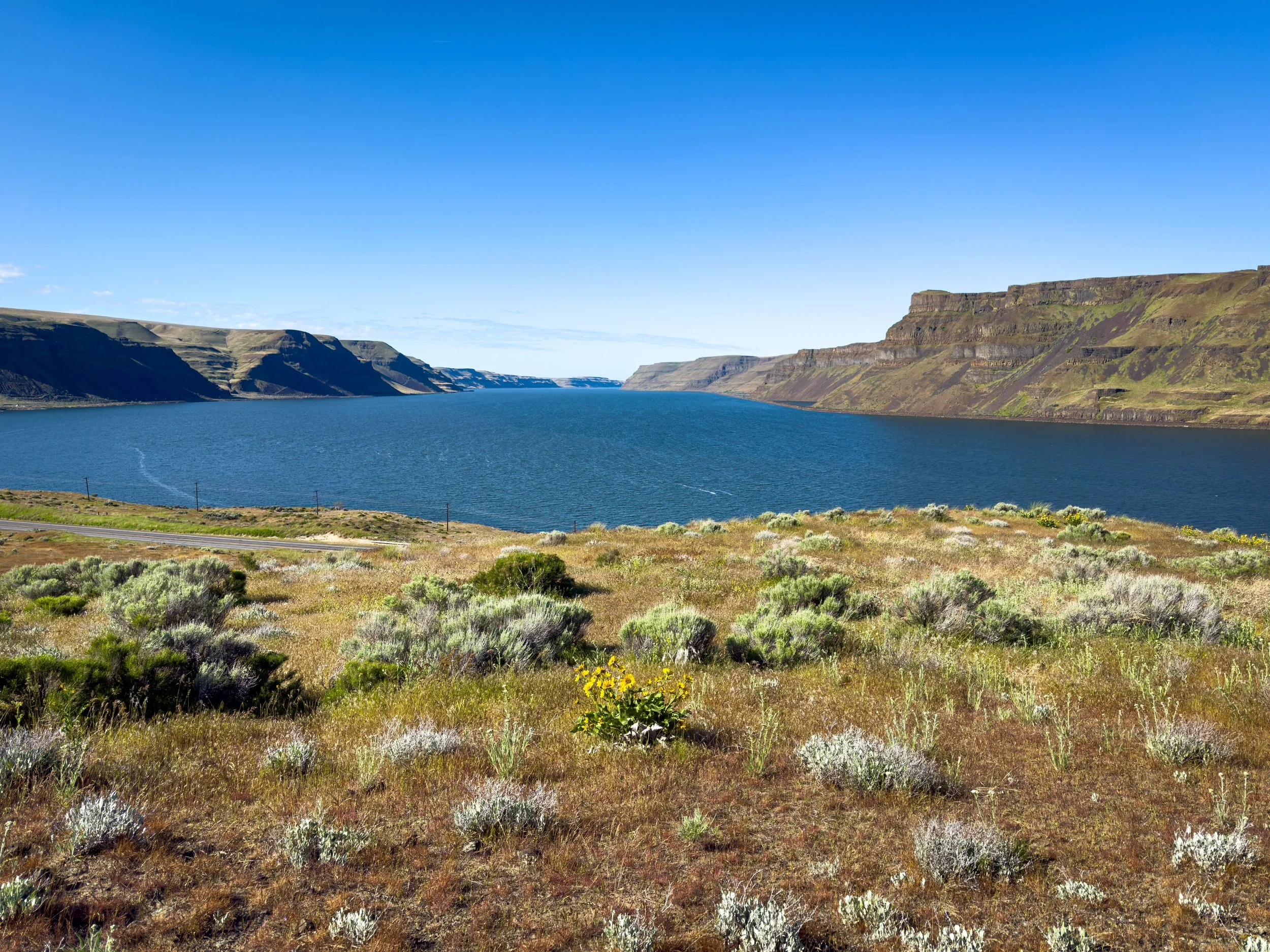
At the top of the ridge, the panorama opens up fully, and it's one of the most dramatic viewpoints on the entire loop. The Twin Sisters stand directly across the valley from you, tall and striking against the plateau behind them. The Columbia River stretches out below. These rock formations are a direct result of the catastrophic Missoula ice age floods that tore through this corridor roughly 12,000 to 15,000 years ago at the end of the last ice age — and standing here looking at what those floods left behind, the scale of it is genuinely difficult to wrap your head around.
Looking behind you from the ridge, there's also a large basalt formation rising from the hillside — a reminder that the geology here goes well beyond just the two main pillars. You'll also notice that the trail approaches private property in this area. The fence line is clearly marked, and while it's tempting to explore further up the valley, please stay on the public trail. There are additional trails in these hills that remain outside the private property if you want to keep exploring.
The Upper Viewpoint
From the first ridge, continue up the hill a bit further in the direction of the river. Up here, a cluster of smaller basalt formations provides its own close-up geological interest, and the river views expand even further — a wider sweep of the Columbia winding through the gap below, with the far bank visible on a clear day. It's a quieter, less-visited part of the loop that's well worth the extra few minutes.
This is also where rattlesnake awareness is most important. The rocky terrain and drier grass in this area are ideal habitat, so stay on the trail, watch where you're stepping, and keep your eyes and ears open — especially in warmer weather when they're most active.
The Climb & Twin Sisters Up Close
From the upper viewpoint, head back down the trail a short distance and watch for a split. To your right, a trail cuts down and across the small valley, heading back in the direction of the dunes. Take it all the way down until you reach another fork, where a trail branches off heading directly up toward Twin Sisters Rock.
This is the most challenging section of the hike — a noticeable incline with some loose rock underfoot — and it's where good hiking shoes really earn their keep. You'll pass a spur trail or two on the way up, but the route is straightforward: keep the formations in your sights and keep climbing. The trail bends around a tight turn near the top and suddenly opens onto a small plateau — and the Twin Sisters are right there in front of you.
There's genuinely no preparing yourself for this moment. From the parking lot, from the ridges, even from the valley below, the formations look impressive. Standing directly on the plateau in front of them, they're simply enormous. Two towering pillars of ancient basalt rising from the cliff edge, and every bit as dramatic up close as you'd hoped they would be. Photos and videos simply do not do them justice — you have to be standing there to feel the full weight of them.
A small trail leads even closer to the base, and another wraps around the front sides of the formations. Please be aware that rock climbing on the Twin Sisters is prohibited by Walla Walla County ordinance — stay on the established trail and enjoy the view from the designated areas. There's more than enough to take in from right where you're standing.
Before heading down, walk in the opposite direction from the rocks, out to the small open viewpoint at the far edge of the plateau. From here you can look back down over the trail system below — the dunes, the ridges, the valley — and get a satisfying bird's-eye perspective on everything you've just explored. When you're ready to descend, a trail to your left provides a slightly faster way down than the route you came up. There's a short section at the start that requires a bit of careful footing, but it levels out quickly and loops around the front of the plateau ridge, depositing you back at the main trail junction.
The Second Ridge
Back at the junction, rather than heading left toward the parking lot, continue straight — this route climbs onto a second ridge on the opposite side of the trail system, and it's one final highlight worth not skipping. It's a moderate climb but a short one, and the views at the top feel completely different from everything you've already seen.
Up here, the perspective shifts to looking down the Columbia River, with long views stretching in both directions and the full sweep of Wallula Gap laid out in front of you. Follow the ridgeline trail to the right, or work your way out closer to the edge for even wider sightlines. At the far end of the ridge, you'll reach a final open viewpoint with a clear look across the river to the far bank — a peaceful, expansive spot to pause and take it all in one last time.
From there, a trail descends back down to the main trail. Turn left, and it leads you directly back to the parking lot.
Final Thoughts
I've driven past Twin Sisters Rock more times than I can count on the way out to Walla Walla over the years — it always caught my eye from the road, but I never stopped. Finally hiking through the trail system that surrounds these formations was a completely different experience from what I expected, and honestly one of the most memorable short hikes I've done in this part of the state. I had no idea there was this whole network of trails out here, or just how impressive the rocks are when you're standing right in front of them.
Twin Sisters Rock is a great option for families, geology enthusiasts, photographers, wildflower chasers, or anyone passing through the Columbia River corridor who wants to stretch their legs and experience something genuinely ancient and dramatic. The hike is short enough to be accessible to almost anyone, and rich enough to keep you exploring for well over an hour if you let yourself wander.
If you're in the area, pair the hike with a drive through Wallula Gap itself — the scenery along the river in both directions is stunning in its own right, and it's a fitting end to a day spent in one of Eastern Washington's most underrated landscapes.
Happy exploring 🌿