
Proxy Falls | Oregon’s Iconic 225-Foot Cascade in Willamette National Forest
Video Walkthrough Guide
Click the Play Button above for the Video Guide, or continue down to read the Full Review.
Quick Facts
- Difficulty: Moderate
- Hike Length: 1.6 Miles
- Elevation Gain: 164 ft.
- Hike Type: Loop
- Pass Required: Yes*
- When to Visit: Spring - Fall**
- Pets: Dogs on Leash
- Kids: Yes
- Facilities: Vault Toilet
*Northwest Forest Pass or America the Beautiful Pass required. Day or Annual options are available here. There is also a pay station at the trailhead.
*Always check weather and road conditions before visiting. Winter snow or Summer wildfires can greatly affect whether the location is accessible. The McKenzie Highway is closed during Winter.
Nestled along Oregon’s McKenzie Highway in Willamette National Forest, Proxy Falls is one of the state’s most iconic and visually stunning waterfalls. Cascading 225 feet over a massive, moss-draped basalt cliff, it’s among the tallest waterfalls in Oregon and a must-see for any waterfall enthusiast. And as a bonus, the short loop trail also brings you to Upper Proxy Falls, a mysterious horsetail waterfall where the water seemingly vanishes into the ground.
With its mix of ancient lava fields, lush old-growth forest, and two unforgettable waterfalls, the Proxy Falls Loop is one of the most beautiful and diverse short hikes in Central Oregon.
Getting There
Proxy Falls is located along McKenzie Highway (OR-242) in Willamette National Forest, about an hour from Bend and 1.5 hours from Eugene. The McKenzie Highway is closed in winter due to snow, so access is generally limited from June through mid-fall, depending on snowpack.
The main parking area is quite large, with space for 20–25 vehicles spread across pullouts on both sides of the road. If the lot is full, roadside parking is common. Amenities include two vault toilets and a picnic table. A Northwest Forest Pass is required—either $5 per day or $30 for an annual pass. They also honor America The Beautiful Passes here.
Hiking the Proxy Falls Loop Trail
The Proxy Falls Loop Trail is 1.6 miles round-trip and rated easy to moderate. The loop begins directly across from the restrooms, where you’ll head briefly alongside the road before curving into the forest.
From the very beginning, the trail impresses with lush greenery. Ferns and vine maples line the path, and massive Douglas-firs tower above. Soon, the trail climbs slightly before opening into a rugged section of ancient lava rock fields—a reminder of the volcanic history that shaped this area. Amid the black rock, vine maples and Douglas-firs push through, creating a dramatic contrast of life reclaiming a barren landscape.
Crossing the lava flow, the trail dips back into the forest, where hemlock, cedar, rhododendron, and bear grass fill the understory. Depending on the season, you may also find vibrant wildflower blooms.
Lower Proxy Falls
At about 0.7 miles, you’ll reach a trail junction with signs for Lower (main) Proxy Falls and Upper Proxy Falls. Head right first for the star of the show.
Within minutes, the forest clears to a viewpoint that frames the falls beautifully. Many visitors stop here, but the best experience is found by continuing down one of the spur trails to the base of the falls. The descent is somewhat steep, and you’ll need to cross a large log over the creek, but the effort is well worth it.
Once at the bottom of the spur trail, take a left until you come across a large fallen tree. Use this to cross to the right side of the creek, and then work your way up to the falls.
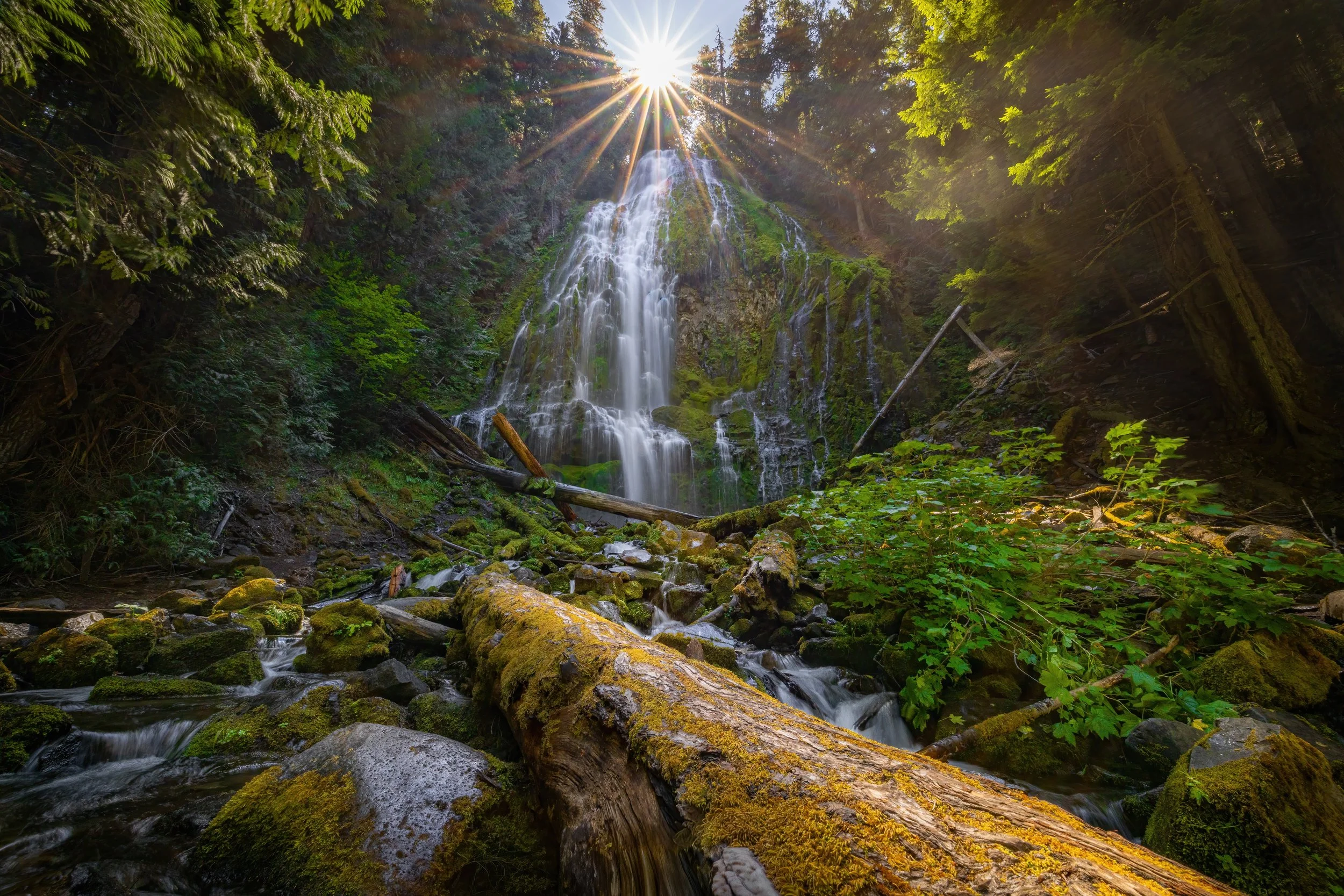
From the bottom of the falls, Proxy Falls is an unforgettable sight. Water sheets gracefully over a 225-foot mossy cliff, spreading into countless rivulets as it tumbles into the lush amphitheater below. Mist fills the air, cooling you on a hot summer day, while Devil’s Club and mosses thrive along the stream. Exploring both sides of the creek offers different angles—one more direct, the other more dramatic as the main flow surges down.
No photo or video can capture how invigorating it feels to stand at the base of Proxy Falls. It’s one of Oregon’s most magical waterfall experiences.
Upper Proxy Falls
Once you’ve soaked in the grandeur of Proxy Falls, return to the junction and continue the loop to the right to Upper Proxy Falls. Another half a mile or so and you’ll come across the second spur trail, which leads to the upper falls. The short trail descends into a shaded gully before revealing a beautiful scene: two streams tumble 130 feet down the cliff, converge, and then cascade over another 25 feet into a pool below.
What makes Upper Proxy Falls so unusual is that the water seems to vanish. Rather than flowing into a creek, it disappears underground, reemerging somewhere further down in the forest. The result is a tranquil, almost mystical setting. Fallen logs, mossy rocks, and a natural amphitheater-like wall make this spot feel like a hidden sanctuary.
Completing the Loop
From Upper Proxy Falls, return to the main trail and continue right on the loop. The path winds through more lush forest, rhododendrons, vine maples, and sections of lava fields before curving back toward the highway. Before long, you’ll spot the road and parking area again.
Final Thoughts
The Proxy Falls Loop is one of Oregon’s most rewarding short hikes. In just 1.6 miles, you’ll experience ancient lava fields, lush forest, and two striking waterfalls—one of which is among the most photogenic in the entire Pacific Northwest.
Proxy Falls is best visited in summer and early fall, when the McKenzie Highway is open and the trails are accessible. It’s a place I try to return to every year, and one I can’t recommend highly enough. Whether you’re chasing waterfalls, photographing nature, or simply looking for a peaceful forest hike, Proxy Falls is a destination that will leave you in awe.
Happy Exploring!


